This column was first published by the nonprofit blog and advocacy organization Greater Greater Washington on June 5.
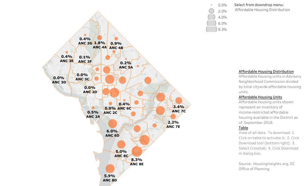
In the entirety of Advisory Neighborhood Commission 3C (Woodley Park/Cleveland Park), 3D (Spring Valley/AU Park), 2D (Kalorama) and 2E (Georgetown/Burleith) there are zero “income-restricted” housing units — homes dedicated for people earning below a certain level. Meanwhile, 6E (Shaw) has 3,477, or 6.8 percent of D.C.’s total, and 8E, which includes Congress Heights, has 4,202 or 8.3 percent of the city’s total.
The D.C. Office of Planning had previously released maps showing which “planning areas” across the city have more or fewer of these affordable homes. At the request of ANC 2B chair (and GGWash Advocacy Committee member) Daniel Warwick, the office created a more granular map showing ANCs, which are 40 elected neighborhood councils spanning the entire District.
2B itself has only 34 of these units, or a tenth of what’s in Shaw just a short distance to the east. Columbia Heights/U Street (1A & 1B), Southwest & the Navy Yard area (6D) and most neighborhoods east of the Anacostia River have the bulk of them.
While D.C. needs more affordable homes overall, including in low-income areas, it’s not fair for the wealthiest parts of the city to have repelled them entirely. This happened because of a combination of high land costs, restrictive zoning, historic preservation rules making homes even more expensive and fear of lawsuits from neighbors who’ve sued other new housing in the past.
The Obama-era federal Department of Housing and Urban Development even told D.C. this disparity violated the Fair Housing Act. Mayor Muriel Bowser’s recent order asking the Office of Planning to set targets for individual planning areas is a start toward pushing for this to change.
